
In my last post, I explained briefly how to find Chicago street names that changed. That is not the only aspect of Chicago address changes that you may encounter. On 22 June 1908 Chicago’s city council passed an ordinance to use a new street numbering system. It went into effect 1 September 1909. The city had grown very quickly over the several decades of its existence. The result was an inconsistent system that made finding places difficult. The 1908 ordinance covered all of the city except the Loop area. Address changes for that area went into effect 1 April 1911.[1]
Plan of Renumbering
When doing Chicago research, you must be aware of these changes. Fortunately, there is an easy way to convert a pre-1909 address to a modern one. For areas outside the Loop, the Plan of Re-numbering City of Chicago was published. It is available as a PDF file at the Chicago History Museum’s website, among other places. The 1911 changes are at the same website. The order is by street name and then divided by odd and even addresses. If you are dealing with a street whose name changed, find the new name here.
The numerical streets, such as Fortieth, may be found under the letter they begin with. Then all that begin with forty will be in numerical order. For example, Fortieth Street follows Forquer. Then Forty-first, Forty-second, etc. show in numerical order. Foster Avenue appears after Forty-ninth Place. Makes sense, right?
Street and Avenue Guides
If you have an older address, say from the 1850s, you may not find its exact address in the conversion table. Perhaps the house no longer stood in 1909. To determine a more exact location, use a Chicago city directory near the time of the address. Every few years city directories included a “Street and Avenue Guide.” Search for that phrase in digitized versions of the city directories or look for it in the table of contents.
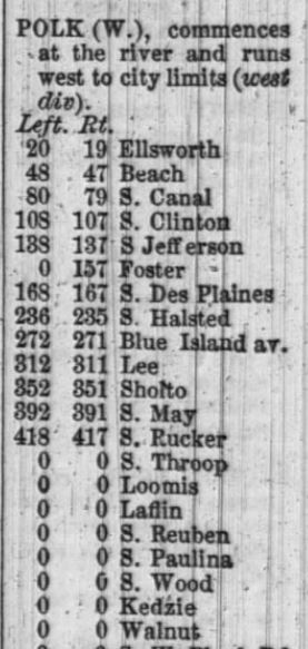
I’ll use 206 W. Polk Street found in an 1859 directory as an example. The Plan of Re-numbering did not include that exact address.

The old numbers are on the right. The two columns represent even and odd addresses.[2] My target address is between 737 and 759 W. Polk. But I wanted historically accurate information. The 1860 directory had the “Street and Avenue Guide” that is closest chronologically. It is alphabetical by street name. This source tells me that 206 falls between Halsted and Desplaines. This agrees with the range I found in the Plan of Re-numbering. I also see that this address would be on the south side of the street because it was on the left, as you’re heading west. ChicagoAncestors website has several links to “Street and Avenue Guides” and city directories.
If you want general information about city directories, read my earlier post. Let me know if you have questions. Happy Hunting!
[1] Plan of Re-numbering City of Chicago (Chicago: Chicago Directory Company, 1909), 2.
[2] Plan of Re-numbering City of Chicago (Chicago: Chicago Directory Company, 1909), 120.
[3] Chicago City Directory for the Year Ending May 1, 1860 (Chicago: Smith and DuMoulin, 1860), 27; digital image, “City Directories for Chicago, Illinois” Fold3 (http://www.fold3.com : accessed June 2017).

I’m trying to locate the current location of 542 Douglas Blvd (as of 1904 to 1906). Using the renumbering document, it looks like this would now be 819 Douglas Blvd (probably W. Douglas Blvd). However, I also see that parts of Douglas Blvd were also renamed (including Independence Blvd, which would mean Douglas went both W-E and N-S!!). How can I determine the current location if it’s been both renumbered and possibly renamed?
LikeLike
Hi Ian,
I find in these cases it is best to go back to the Street and Avenue Guide found in the directory closest to the time in question. The 1905 Chicago directory has a such a guide. According to that resource, 542 was between Lexington and Polk. Douglas Blvd. was renamed Independence Blvd. at 3800 West. If you look at a modern map, such as Google Maps and compare to the description of Douglas Blvd found in the 1905 street guide, it will make more sense. In 1905 Douglas Blvd. started at Garfield Park and ran south to Independence Square, then east to Douglas Park. The modern map shows that Independence Blvd. starts a Garfield Park and when it gets just past 14th Street, it heads east, but then is known as Douglas Blvd.
The Street Renumbering says that 542 Douglas Blvd became 819 Douglas Blvd. When you map that, it looks like it’s about a block off. I would use the 1905 street guide as the better source, which states that it was between Lexington and Polk. I hope that helps!
LikeLike